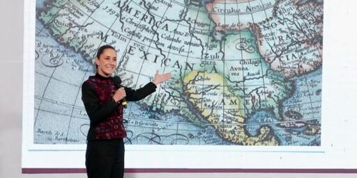
President Sheinbaum “used her Wednesday morning news conference to show a world map dating from 1607. The map labeled North America as Mexican America and already identified the Gulf of Mexico as such, 169 years before the United States was founded,” The New York Times reports.


I’m trying to find her source map and I am not finding it. I am also finding other 1607 maps that contradict this. Note that I want this to be true because it pisses off Trump fans, but I’m not sure that this was exactly a common view of North America at the time.
Some 1607 examples:
https://turismo.b-cdn.net/wp-content/uploads/2023/08/Map-of-Western-Hemisphere-from-1607-America-scaled.jpg
https://c8.alamy.com/comp/2RKH966/old-17th-century-dutch-vintage-world-map-designation-of-the-christian-world-print-by-jodocus-hondius-1607-2RKH966.jpg
This one is by Mercator. It does seem to call the region New Spain, but that is not the same thing: https://images.squarespace-cdn.com/content/v1/539dffebe4b080549e5a5df5/1681406870328-59NYYF9DTFGLNTPCG2VX/1607-Antique-World-Map-Mercator-typus-orbis-museum-outlets.jpg?format=2500w
Sorry, this one you have to go to the website and it has annoying zoom features: https://fineartamerica.com/featured/1-vintage-map-of-the-world-1607-cartographyassociates.html
Note, I’m not saying the map is a fake or anything. I have no idea about its authenticity. But it does not seem to be the name the majority of cartographers were using.
Well, it seems that the territory in question later became what is known as the Mexican Cession of 1848.